Drone Sensors Explained: A Comprehensive Guide
Drones, also known as Unmanned Aerial Vehicles (UAVs), have become an integral part of various industries, from photography and agriculture to delivery services and surveillance. One of the key components that enable drones to perform their diverse functions is their sensors. These sensors provide the necessary data for navigation, stability, and task execution. In this comprehensive guide, we will delve into the different types of sensors used in drones, their functionalities, and their applications.
Types of Drone Sensors
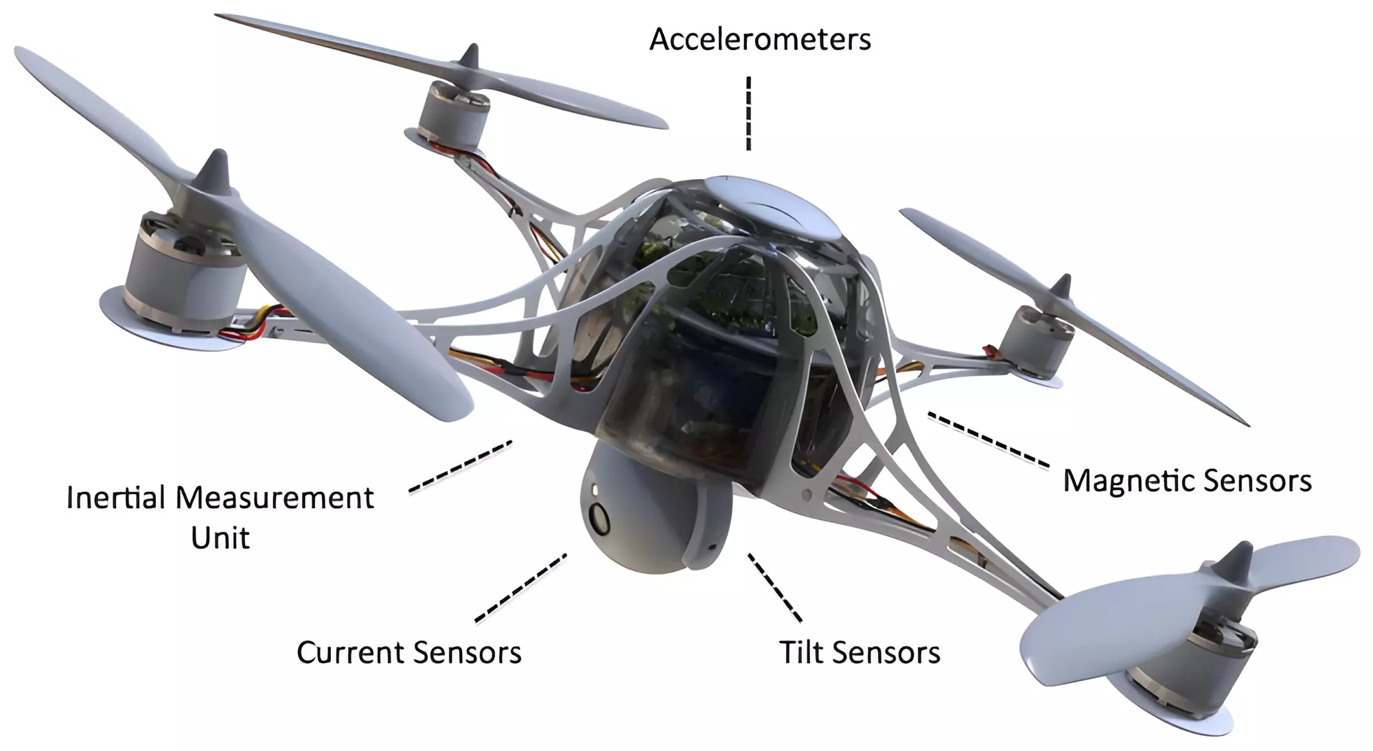
1. Inertial Measurement Unit (IMU)
The Inertial Measurement Unit (IMU) is a crucial sensor in drones, responsible for maintaining stability and orientation. It consists of accelerometers, gyroscopes, and sometimes magnetometers. The accelerometer measures linear movement on different axes, while the gyroscope measures angular velocity, helping the drone maintain its orientation. Magnetometers, when included, aid in compass calibration by detecting the Earth’s magnetic field.
2. GPS Module
A GPS module is essential for navigation and location tracking. It allows drones to pinpoint their position on Earth, follow pre-programmed routes, and return to the home point. GPS data is also crucial for geotagging in aerial photography and videography, ensuring accurate mapping and surveying.
3. Barometer
Barometers measure atmospheric pressure, providing altitude data crucial for flight stability and navigation. By comparing pressure changes, the drone can determine its altitude above ground level, ensuring safe flight and precise landings. This sensor is particularly vital in environments where GPS signals may be weak or unreliable.
4. Vision Sensors
Vision sensors, including cameras and optical flow sensors, enhance a drone’s perception of its environment. Cameras capture images and videos for various applications, from filmmaking to inspection. Optical flow sensors assist in maintaining position by analyzing movement relative to the ground, providing stability during flight, particularly indoors or in GPS-deprived locations.
5. LiDAR Sensors
LiDAR (Light Detection and Ranging) sensors use laser pulses to measure distances to objects, creating 3D maps of the environment. This technology is invaluable in applications requiring high precision, such as topographic mapping, obstacle detection, and autonomous navigation in complex environments.
6. Infrared Sensors
Infrared sensors detect heat signatures, making them useful for applications like search and rescue, wildlife monitoring, and industrial inspections. They can identify temperature variations, locate living beings in low visibility conditions, and detect heat leaks in infrastructure.
7. Ultrasonic Sensors
Ultrasonic sensors emit sound waves and measure the time taken for the echo to return, determining the distance to objects. These sensors are commonly used for obstacle avoidance and altitude measurement, especially in low-light or GPS-challenged environments.
8. Magnetometer
The magnetometer is akin to a digital compass, measuring magnetic fields to determine orientation relative to the Earth’s magnetic poles. It plays a critical role in flight control systems, helping drones maintain a stable heading and navigate accurately.
Applications of Drone Sensors
Agriculture
In agriculture, drones equipped with multispectral and hyperspectral sensors can analyze crop health, monitor irrigation, and optimize resource allocation. This data-driven approach enhances yield and reduces waste, making farming more efficient and sustainable.
Infrastructure Inspection
Drones equipped with high-resolution cameras and LiDAR sensors are revolutionizing infrastructure inspection. They provide detailed visual and structural data on bridges, power lines, and buildings, identifying issues before they become critical, thus ensuring safety and reducing maintenance costs.
Environmental Monitoring
Environmental agencies use drones with various sensors for monitoring climate change, tracking wildlife, and assessing natural disasters. LiDAR and infrared sensors are particularly useful in mapping terrain changes and identifying hotspots in forest fires.
Search and Rescue
In search and rescue operations, drones equipped with infrared sensors can locate individuals in challenging terrains or adverse weather conditions. Their ability to cover large areas quickly and access hard-to-reach locations makes them invaluable in emergency situations.
Delivery Services
For delivery services, drones rely on GPS and vision sensors to navigate efficiently and accurately. These sensors ensure packages are delivered to the correct location, optimizing logistics and reducing delivery times.
Challenges and Future Developments
Integration and Compatibility
Integrating multiple sensors into a single drone poses challenges in terms of compatibility and data synchronization. As technology advances, manufacturers are focusing on creating more cohesive systems that allow for seamless integration of diverse sensors.
Data Processing and Management
The vast amount of data generated by drone sensors requires efficient processing and management systems. Developing algorithms and software that can analyze and interpret this data in real-time is a key area of ongoing research and development.
Miniaturization and Cost Reduction
As demand for drones increases, there is a push towards miniaturizing sensors and reducing costs. Advances in sensor technology are making it possible to create smaller, more affordable sensors without compromising on performance, broadening the scope of drone applications.
Conclusion
Drone sensors play a pivotal role in expanding the capabilities and applications of drones across various industries. From maintaining flight stability to providing critical data for decision-making, these sensors are the backbone of modern UAV technology. As advancements continue, we can anticipate even more sophisticated sensors that will further enhance the functionality and versatility of drones, opening new possibilities for innovation and efficiency.
Share this content:

Post Comment